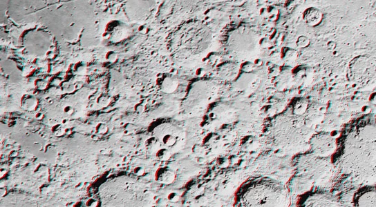
The Moon has always been an endless source of inspiration for humanity, not only because of its beauty but also for the scientific potential hidden on its surface. Recently, Jeffrey Ambroziak, a renowned inventor in the field of 3D cartography, utilized data from NASA’s Lunar Reconnaissance Orbiter (LRO) to create the first-ever three-dimensional map of the Moon. This is not just a technological leap but also a bridge bringing us closer to the extraterrestrial world.
This map offers a completely new experience, allowing viewers to explore the Moon’s terrain from every angle and distance, far surpassing the limitations of traditional 3D technology. Instead of merely creating a depth effect through overlapping two images as seen in 3D movies, Ambroziak’s proprietary algorithm alters pixel brightness and size based on their location, thus generating a realistic and vivid image. “We are not just creating a map but providing humanity with a new perspective on Earth’s only natural satellite.” Ambroziak shared.

Notably, the current map covers only 8% of the Moon’s surface, but the potential for expansion is immense. This project is being crowdfunded on Kickstarter, with a goal of USD 5,000, of which nearly 50% has already been reached. If sufficient support is received, the research team will continue to complete a map that encompasses the entire Moon.
“When technology can transform dry data into vivid imagery, we are taking a giant leap in understanding and inspiring space exploration.”
The project has drawn attention not only from scientists but also from the U.S. military, particularly in applying 3D mapping technology for space studies and strategic operations. Beyond the Moon, Ambroziak has applied this technology to create detailed maps of Mars and Antarctica, locations that are highly challenging but hold invaluable insights into planetary history and structure.
The detailed data from NASA’s LRO, recently released, plays a crucial role in making this 3D map more accurate and useful. The LRO’s high-resolution camera has captured the finest details of the Moon’s terrain, from deep craters to rugged highlands. This data not only provides a clearer understanding of the Moon’s structure but also supports future exploration missions. “This is not just a map but a scientific tool helping us prepare for space conquest missions.” NASA affirmed in its 2023 report.
The 3D Lunar Map project not only opens a new chapter in cartography but also ignites humanity’s curiosity about the universe. From understanding the Moon’s surface to exploring distant planets, the future of space exploration is bound to bring even more astonishing discoveries.


HPX24h > Space > 3D Lunar Map: A New Gateway to Understanding the Universe
Top Reads from This Category
Space
Over 100 Billion Planets in the Milky Way: Astonishing Discoveries About the Universe
Space
Three Earth-Like Planets That Could Support Life: New Discovery from NASA
Space
Could Our Universe Have Collided With Another Universe Billions of Years Ago?
Space
The Two Largest Black Holes Ever Discovered
Space
Gamma Ray Bursts and the Key to the Chemical Composition of the Early Universe
Space
The Smallest Star System with Three Exoplanets Found by NASA’s Kepler
Space
The Milky Way’s Central Black Hole: The Asteroid Annihilator
Discover New Topics
Health
Fruits That Can Spike Blood Sugar Levels: Be Cautious
Science
NSF Job Cuts: Who Benefits and Who Bears the Consequences?
Science
Science Could Regrow Your Lost Arm… on a Monkey’s Body
Parenting Tips
Why Your Child Might Be Coughing Disruptively During Sleep?
Parenting Tips
How to Talk to Children About Alcohol (Ages 6-8)
Fitness
Aerobic and Anaerobic: The Right Training Secrets for Overall Health and Strength
Health
E. Coli In The Gut May Trigger A ‘Chain Reaction’ Leading To Parkinson’s Disease
Healthy Eating
The Reasons You Should Eat These Fruits During Pregnancy to Reduce Fatigue and Anemia
Space
Exploring Saturn’s Moon Phoebe: Planet-Like Features and Characteristics
Science
Discover Blood Testing Technology Without a Visit to the Doctor
Healthy Eating
Foods That Support Depression Reduction: The Latest Scientific Nutritional Choices
Fitness
hould You Do Cardio or Lift Weights to Burn Calories More Effectively
Animals
Rats Help Each Other: When Compassion Emerges from Small Creatures